Exporting multiple session maps

classic Classic list List threaded Threaded
4 messages Options
Reply | Threaded
Open this post in threaded view
|

Exporting multiple session maps

DorEdel
Hi

I have a database with couple of maps because of reset odometry event (Odom/ResetCountdown), between the maps there are no loop closures (as I expected because I went in a straight line) .
Now my problem is that when I export a 3D cloud the only cloud I get is from the last map.
Is there a way to export all the maps in a single 3D cloud?

thank you
Reply | Threaded
Open this post in threaded view
|

Re: Exporting multiple session maps

matlabbe
Administrator
Hi,

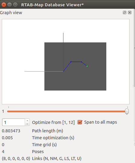
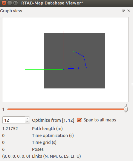
The only way to export multiple sessions separately is to use the database viewer tool. When opening a database with the Database Viewer, open the Graph View panel (View->Graph view). On the "Optimize from" box, set the node id you want to optimize the map. In this small example, I did 2 independant small maps (hitting Reset odometry while mapping and making sure there a re no loop closures between maps):


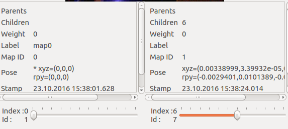
You can see in the other panel to which map the nodes belong (under "Map ID" label):


Then when you hit the Export cloud or View cloud options, the current graph is used to assemble the map. You can save separately the point cloud of the different sessions. Unfortunately, the database viewer doesn't have as many options than RTAB-Map app. I opened an issue for that.

cheers,
Mathieu
Reply | Threaded
Open this post in threaded view
|

Re: Exporting multiple session maps

DorEdel
This post was updated on .
Wow thanks!

I have some questions:
1. can I export a single cloud for all the sessions?
    I mean if I have a database with 3 (or 300) sessions can I export all of then to a single map?

2. is there any option of showing the 3d cloud of a single session in the standalone app in the 3d map window?
Reply | Threaded
Open this post in threaded view
|

Re: Exporting multiple session maps

matlabbe
Administrator
Hi,

1. well, having multiples maps (not connected between each other) in the same point cloud file would be messy (unless we offset them by the size of the previous map when exporting). For convenience, I could add an option to extract all maps from the database instead only the current visualized one. They would be exported in different point cloud files (e.g. one *.pcd per session). An option to export them in the same file with offset could also be added (can be a nice option indeed to visualize all maps in the database).

2. No. Note that if you are mapping areas that will never be connected (they don't overlap), it may be better to create different databases, otherwise the loop closure detection algorithm will take a lot of processing time (to find loop closure with all other maps) for nothing.

I updated the opened issue above with your suggestions.

cheers