Velodyne VLP16 in RTab map

classic Classic list List threaded Threaded
7 messages Options
Reply | Threaded
Open this post in threaded view
|

Velodyne VLP16 in RTab map

APOS80
I’ve seen that the newest version has support for the VLP16.

I would like to see an example.
Construction surveyor since 2006 and tech-nerd.

I also use WebODM!
Reply | Threaded
Open this post in threaded view
|

Re: Velodyne VLP16 in RTab map

matlabbe
Administrator
Hi,

I am still working on more complex examples involving external IMUs/cameras at the same time, but for a basic example using the LiDAR alone, here what you need to do.

1) In Preferences, reset all settings to defaults, then click on "LiDAR 3D ICP" button to load a preset.


2) Under Source panel, set camera driver to None, then set LiDAR driver to VLP16, then scroll down to adjust the IP of the LiDAR (you can use a web browser to look at the current LiDAR config, set host IP to your computer receiving the scans):
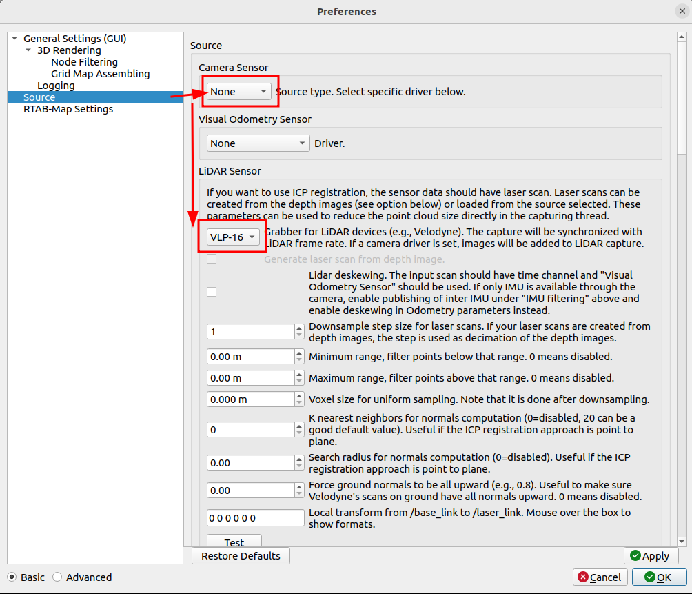
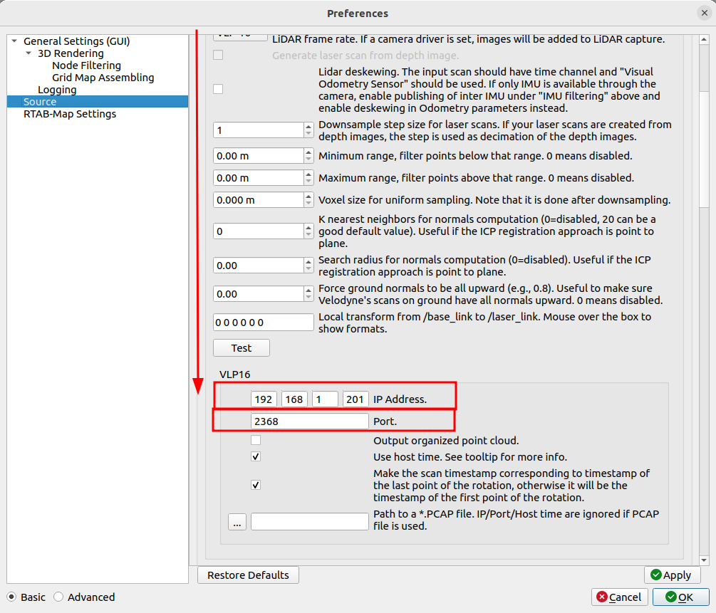
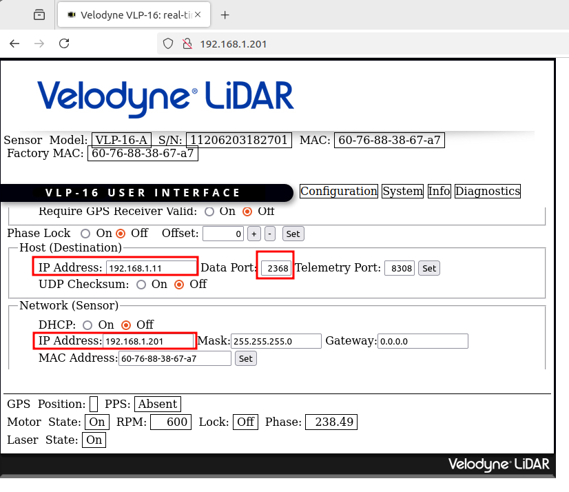

3) Go back to main window, click on "New Database", then click on "Start":
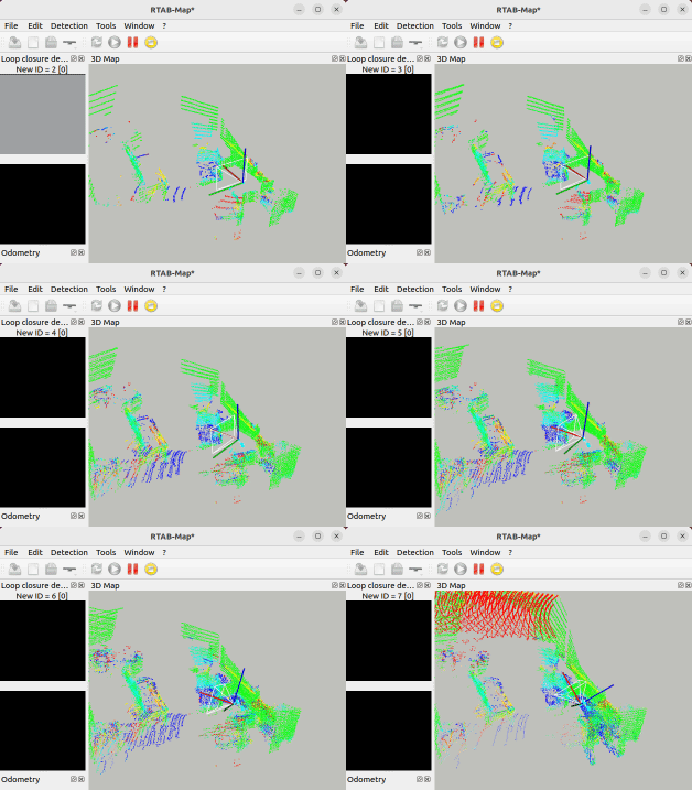

When using the LiDAR alone, there is no visual loop closure and if ICP odometry gets lost, it may be difficult to recover, so make sure the lidar field of view is not blocked and avoid fast motions.

cheers,
Mathieu
Reply | Threaded
Open this post in threaded view
|

Re: Velodyne VLP16 in RTab map

robert
Hi,
I have some experience with ICP odometry "the LiDAR field of view is not blocked and avoid fast motions."

Do you have any suggestions for solving this issue? I am using a VLP-16 on a UAV and was wondering if IMU information from a Pixhawk 6X could help. Do you have any relative examples?
Thanks.
Reply | Threaded
Open this post in threaded view
|

Re: Velodyne VLP16 in RTab map

matlabbe
Administrator
With ROS, we can easily use IMU (which is recommended) with lidar. See this example: https://github.com/introlab/rtabmap_ros/blob/ros2/rtabmap_examples/launch/lidar3d.launch.py, either provide imu_topic and/or a fixed_frame_id which could be your pixhawk odom frame.

Note however that as soon ICP fails, you could still get lost. You could enable auto odom reset with Odom/ResetCountdown=1, which would reset icp_odometry to last known pose and try register next lidar scans from there.
Reply | Threaded
Open this post in threaded view
|

Re: Velodyne VLP16 in RTab map

robert
Hi there,
Thanks for the link. I tried running the simulation, but the results weren't good in localization mode. I'm wondering if RTAB-Map requires the /scan topic during the mapping phase. I noticed that the LiDAR in the Gazebo environment only publishes the /velodyne_points topic.

Regards,
Robert
Reply | Threaded
Open this post in threaded view
|

Re: Velodyne VLP16 in RTab map

matlabbe
Administrator

With a 3D lidar, RTAB-Map doesn't need /scan, but /scan_cloud topic, which could be a remap from /velodyne_points -> /scan_cloud.

If you try velodyne in simulation, you may check the Husky examples here:
https://github.com/introlab/rtabmap_ros/tree/ros2/rtabmap_demos#clearpath-husky-nav2-3d-lidar-and-rgb-d-slam

Note that to get good lidar generation in gazebo ignition, do what is explained here (ref issue).

cheers,
Mathieu
Reply | Threaded
Open this post in threaded view
|

Re: Velodyne VLP16 in RTab map

robert
Hi Mathieu,
Thanks for your detailed response. Sure, I will give it a try.

Regards,
Robert