rtabmap.launch used with subscribe_rgbd and subscribe_scan_cloud
|
This post was updated on .
Dear people.
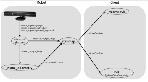
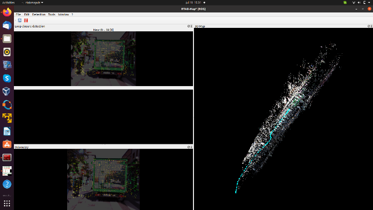
I do have a Asus Xtion Pro and a roslaunch was implemented based on kinect as shown in the picture:  I may say that the 3D mapping was successful, well some problems with the odometry. However, I do have a laser data set and a rgb data set and I wanted to applied the previous roslaunch but I could not make it work, specially with the rgbd_odometry so I decided to search for another kind of odometry and I found a ros package (rf2o_laser_odometry_node) that could calculate odometry based on 2D laser scan, so I converted the 3D pointcloud using the pointcloud_to_laserscan_node. Then, I wanted to used the rtabmap_ros, but I could not open rtabmapviz and I could not produce any cloud_map. So, I decided to used rtabmap.launch using subscribe_rgbd and subscribe_scan_cloud to true. Now, I can see the map in rtabmapviz but not in rviz and also I the loop closure detection between images is very poor I mean practically zero. I often get this INFO in the terminal Assembled 0 obstacle and 0 ground clouds (69 points, 0.000042s) I do not know whether rtabmap.lauch can be used with subscribe_rgbd and subscribe_scan_cloud. I suppose it can be used but maybe I am using the wrong parameters or wrong values. I post the rtabmap.launch code. <include file="$(find rtabmap_ros)/launch/rtabmap.launch"> <arg name="rtabmap_args" value="--delete_db_on_start --Grid/FromDepth true --Optimizer/GravitySigma 0.3" /> <arg name="frame_id" value="camera_link"/> <--param name="subscribe_depth" type="bool" value="false"/> <--param name="subscribe_rgb" type="bool" value="false"/> <arg name="subscribe_rgbd" value="true"/> <aeg name="subscribe_scan_cloud" value="true"/> <--param name="rtabmapviz" type="bool" value="true" /> <arg name="approx_sync" value="true"/> <arg name="visual_odometry" value="false" /> <remap from="scan_cloud" to="/camera/depth_registered/points"/> <remap from="rgbd_image" to="/rtabmap/rgbd_image"/> <remap from="odom" to="/rtabmap/odom"/> <arg name="queue_size" value="10"/> <--param name="Vis/MinInliers" type="int" value="6"/> <--param name="Grid/CellSize" type="string" value="5"/> <--param name="Odom/MinInliers" type="string" value="6"/> <--param name="SURF/HessianThreshold" type="int" value="100"/> <--param name="Grid/RangeMax" type="double" value="0"/> <--param name="Grid/FromDepth" type="bool" value="true"/> <--param name="Grid/MaxObstacleHeight" type="string" value="5.0" /> <--param name="Odom/ResetCountdown" value="0" /> <--param name="RGBD/NeighborLinkRefining" type="string" value="true"/> <--param name="RGBD/ProximityBySpace" type="string" value="true"/> <--param name="RGBD/AngularUpdate" type="string" value="0.01"/> <--param name="RGBD/LinearUpdate" type="string" value="0.01"/> <--param name="RGBD/OptimizeFromGraphEnd" type="string" value="false"/> <--param name="Grid/FromDepth" type="string" value="false"/> <--param name="Reg/Force3DoF" type="string" value="true"/> <--param name="Reg/Strategy" type="string" value="0"/> <--param name="RGBD/OptimizeMaxError" type="string" value="0"/> <arg name="odom_tf_angular_variance" value="0.001"/> <arg name="odom_tf_linear_variance" value="0.001"/> </include> I post also the map in rtabmapviz  Any help I do appreciate it, thank you |
|
Administrator
|
Hi,
Do you mean from a real lidar? 2D or 3D? or a simulated one from the xtion point cloud? lidar odometry nodes would not work well with scan data simulated from xtion point cloud. If it is a real lidar, you could look at this example: http://wiki.ros.org/rtabmap_ros/Tutorials/SetupOnYourRobot#Kinect_.2B-_2D_laser cheers, Mathieu |
«
Return to Official RTAB-Map Forum
|
1 view|%1 views
| Free forum by Nabble | Edit this page |

